• General
• General
Seasonal changes and weather bring external stresses to both buried pipelines, as well as overhead transmission infrastructure. Freeze, thaw, snowmelt, rain, tectonic movements, subsurface mining, loss of vegetation, encroachments from human activity, and even wildfires — all have repercussions that may affect soil stability. Pipeline and utilities have integrity management groups of geoscientists and field ops dedicated to both prediction and response to geohazards.
Land slips and tree canopy changes from both natural and human activity.
Early detection of threats and minimizing risk is dependent on two factors:
1. ACCURACY
Satelytics’ Constant Vigilance™ algorithms process the highest resolution data down to 30 cm pixels squared over an entire asset area to specify where threats exist. Our geohazard tools include measurements for:
Our algorithms measure light reflectance in the infrared spectrum, and have been employed over topographies worldwide. In instances where vegetation and slope movements occur, lateral and vertical changes can be calculated. These algorithms have been run and rerun to provide confidence in the outcome. Each algorithm is run on every pixel, every time, removing the error of human inspection.
2. RAPID RESPONSE
Now that the threat has been identified, it must be quickly shared with users to be effective. If days or weeks lapse between the time the aerial data is gathered and when alerts are delivered to response staff, then the damage will have likely occurred.
Satelytics as a company is agnostic to the source of data. We collect information from any suitable platform offering spectral data. Though every challenge is unique, most of our projects use satellite imagery because satellites cover large geographies and have downlink infrastructure in place for timely delivery of large data sets to the cloud. Think about gathering millions of pixels over a right-of-way or pipeline network — this equates to terabytes of data. Satellites are the only platform able to cover and transfer that much data quickly.
Satelytics has invested heavily into automating the preprocessing of large sets of data before it hits our algorithms. This automation step means SPEED, getting data from any source lined up for algorithmic processing on the cloud in a matter of minutes from when it is acquired.
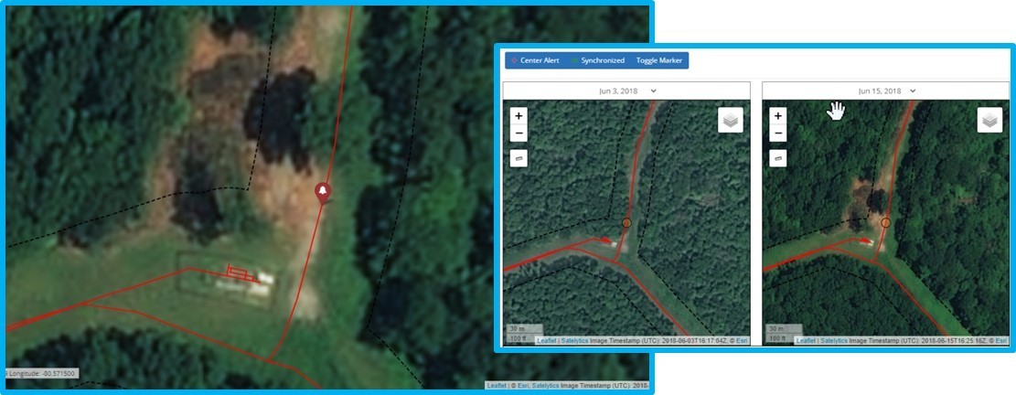
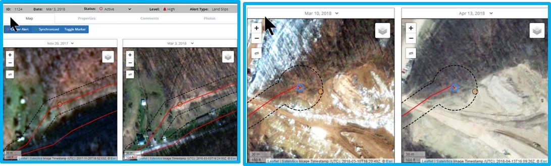
Land clearing and vegetation in the ROW, as well as land shift and exposed soils from seasonal change.
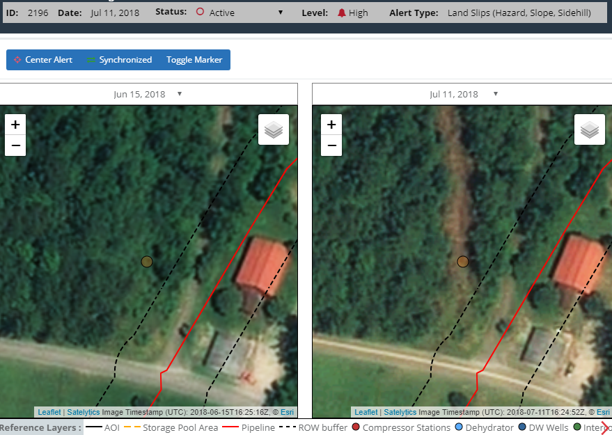
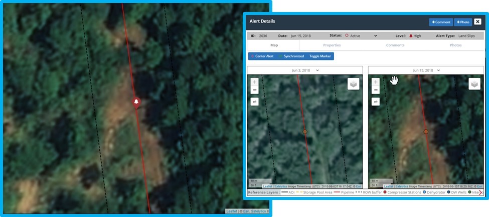
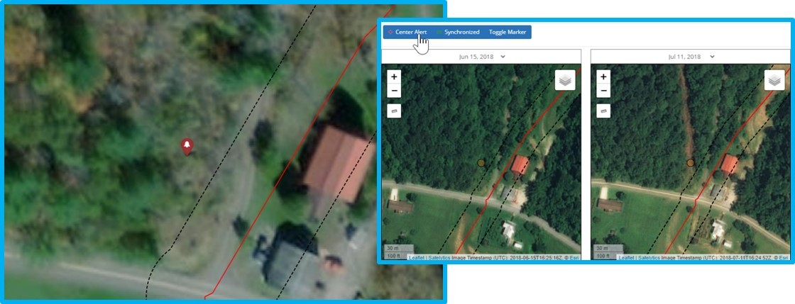
When data capture and preprocessing are completed, the algorithms go to work looking for irregularities and conditions that precede or identify land movements. If a slip has occurred, our algorithms even provide automated measurement of the square footage of the affected area, with alerts sent to our customers in a matter of hours after the data is obtained.
Satelytics’ midstream and utility customers demand the most current geohazard data to inform their decision-making to prevent damage to infrastructure and the environment. Call us today to see how these tools can simplify your workflow.
Satelytics Inc., www.satelytics.com, is a cloud-based geospatial analytics software suite. Multispectral and hyperspectral imagery is gathered from satellites, UAV, planes, and fixed cameras, and processed to provide both alerts and qualitative results for our customers. Data can be gathered up to a daily basis, and results are sent to customers in hours. This includes the specific problem, location, magnitude, and even qualitative information, which minimizes cost, impact, and operational disruption for our clients.
Toledo, OH – December 15, 2020. For more information, contact David Dunham, ddunham@satelytics.com, (o) (419) 728 0060 extension #101, (c) (701) 213 0294.
We use cookies to analyze our web traffic and to enhance your experience. By continuing to view this website, you agree to our use of cookies.
Our Privacy Policy