
• Water & Wastewater
• Water & Wastewater

“Satelytics water quality measurements can bring so much value to areas of the world where sensors may not be available... A game changer for these emerging countries that may not have the resources to protect their environments.”
Last week we introduced The Nature Conservancy (TNC) and its industry partner’s Pee Dee River project with Satelytics from the perspective of Eric Krueger, Director of Science and Stewardship at TNC. Today we discuss the specifics of that project and examine how Satelytics’ customers increase their scientific understanding of processes within their watersheds.
The Pee Dee River project focused on the measurement of manganese and turbidity tied to hydrological events. This scope was defined after discussions with industry and local water department partners and prioritization of the water quality challenges that had affected their operations. Here is why these topics are important:
Turbidity – a measure of cloudiness caused by very small particles that are dissolved in water. Turbidity is also referred to as sediment loading. As turbidity increases, water treatment processes are challenged, which drive up costs for water users, both industry and municipal.
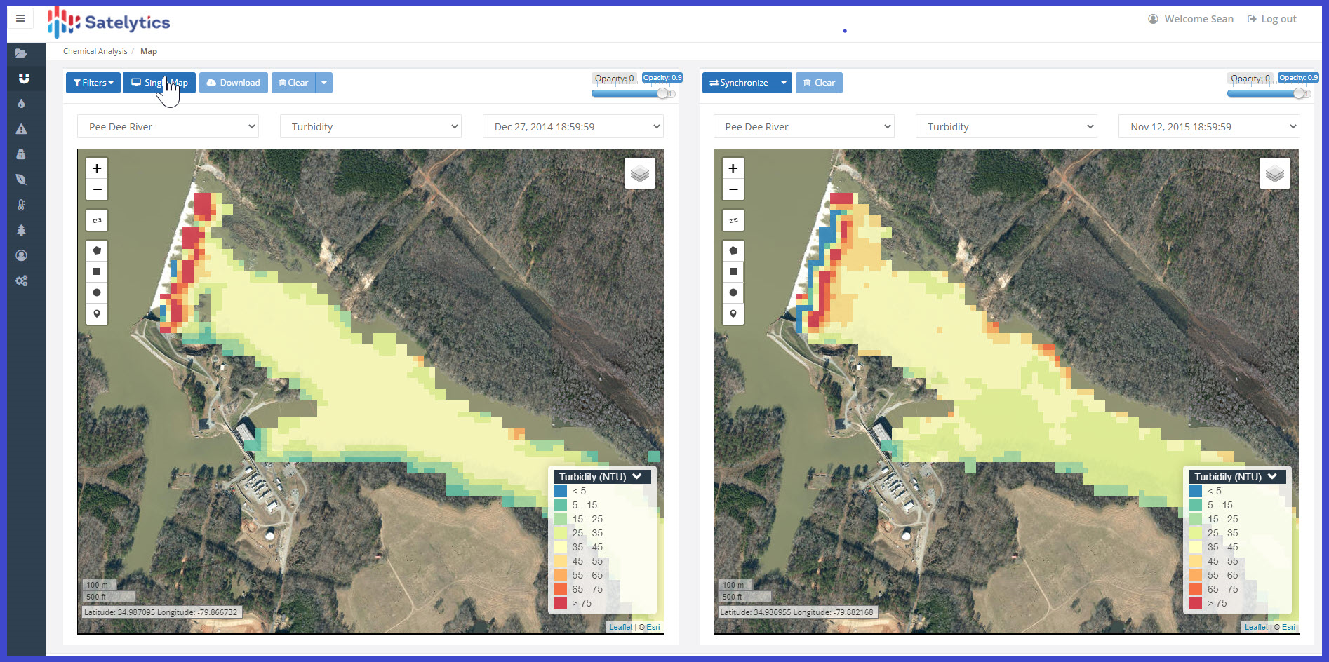
Turbidity measured in nephelometric turbidity units (NTU) on the Pee Dee River over two time series.
Manganese – an essential nutrient for photosynthetic actions in vegetation in low concentrations. In high concentrations it can be harmful for human and wildlife consumers and form deposits on sensors and water treatment equipment.

Left – Manganese measured in parts per billion (PPB) on the Pee Dee River over two time series.
Right – Turbidity (NTU) measured on the Pee Dee River over two time series.
In Mr. Krueger’s words, “traditional sampling techniques offer point values at relatively few locations in a watershed area and are often separated by hours if not days or weeks, making it difficult to put a meaningful story together.” With Satelytics’ geospatial analytics, every pixel, over the entire area of interest was analyzed for manganese and turbidity at the exact same time!
The TNC team looked back for dates of known hydrological events like spring flooding, rain, and wind, and then directed Satelytics to process high resolution archival satellite imagery that coincided with the upsets. The data, when combined with historical flow records, allowed TNC and its industry partners to identify areas where “sediment sitting” was happening during dry times and then would be released downstream during an upset event. Subsequent Water Fund Network projects then targeted these physical locations in the watershed for vegetation restoration, dam maintenance or removal, and improved flood planning. For the Pee Dee River, this meant an improvement in health, as well as decreased turbidity pretreatment costs for consumers!
For manganese management, areas of the watershed were identified that may need restoration of vegetative filtering through improved holding ponds or marsh areas. Furthermore, the data allowed water treatment facilities to fine tune their manganese reduction processes, knowing the range of manganese (PPB) possible from their intake locations.
Eric stated, “Putting in the effort beforehand to understand historical weather and deployed sensor data leading up to when Satelytics processed the imagery allowed for the most complete understanding of manganese and turbidity processes.” In addition, “you could send an army and a billion dollars into the field and not get data like this.”
Founded to solve challenges in the water/wastewater industry, Satelytics serves up a completely unique data set to customers like Eric and his industry clients who seek a deeper understanding of the complex mechanisms at work in their watersheds, rivers, and reservoirs. Measurements include:
Satelytics Inc., www.satelytics.com, is a cloud-based geospatial analytics software suite. Multispectral and hyperspectral imagery is gathered from satellites, UAV, planes, and fixed cameras, and processed to provide both alerts and qualitative results for our customers. Data can be gathered up to a daily basis, and results are sent to customers in hours. This includes the specific problem, location, magnitude, and even qualitative information, which minimizes cost, impact, and operational disruption for our clients.
For more information, contact David Dunham, ddunham@satelytics.com, (o) (419) 728 0060 extension #101, (c) (701) 213 0294.
We use cookies to analyze our web traffic and to enhance your experience. By continuing to view this website, you agree to our use of cookies.
Our Privacy Policy