
• General
• General
Minimize consequence through early detection to limit “loss of product or revenue, remediation, and environmental impact.”
An Emerging Problem
Recently, I have witnessed a concerted effort by the oil & gas industry to discuss methane emission calculations, assess their accuracy, and refine them where necessary. An emerging consensus among these organizations is to employ satellite data to inform these efforts. These companies recognize that satellites offer the broadest coverage of all currently operational platforms. Satelytics offers a solution that sets the standard for these efforts.
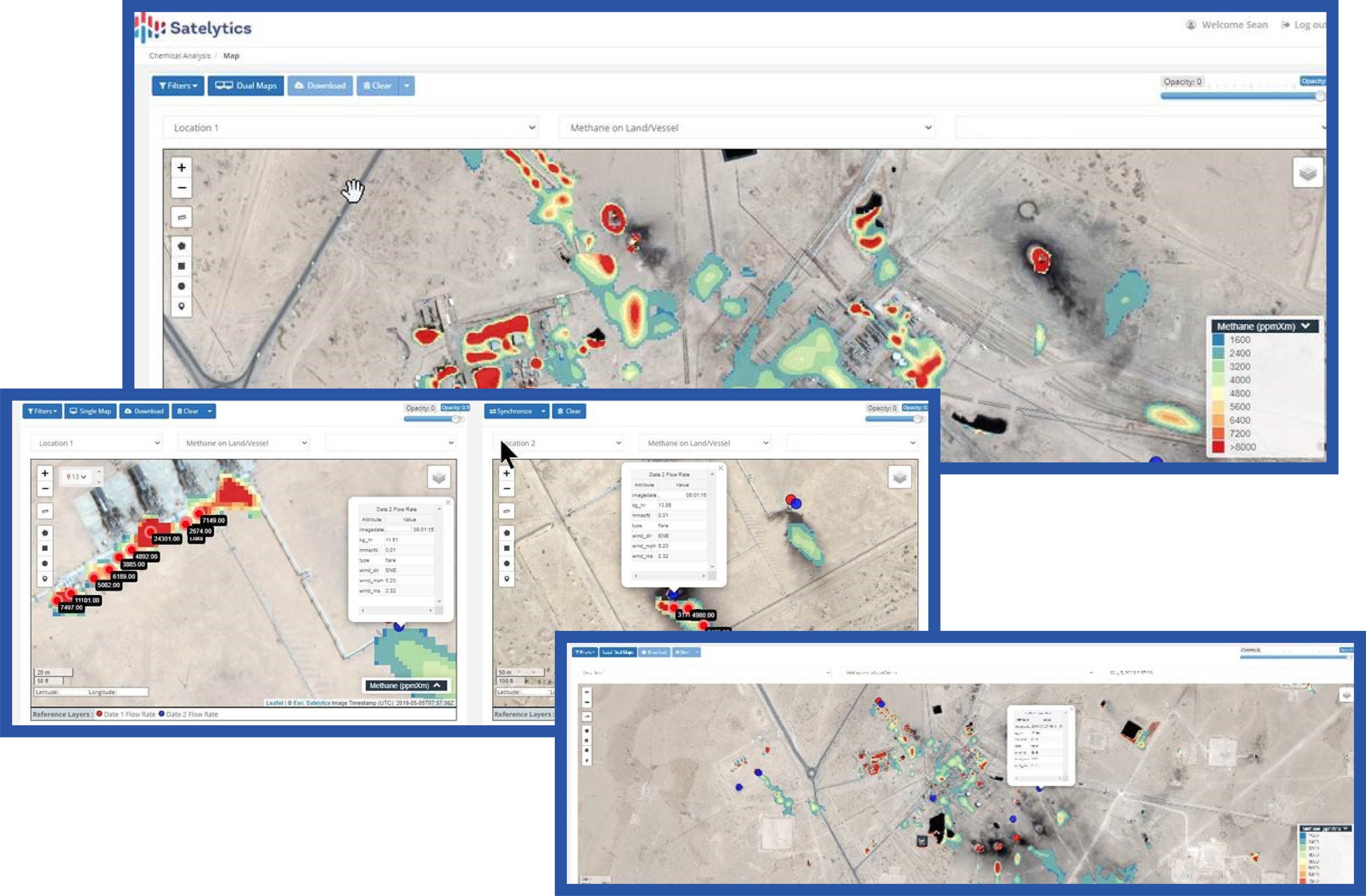
Satelytics is a software company that has developed a suite of algorithms to both IDENTIFY and QUANTIFY methane to parts per million (PPM) levels. These same algorithms also back-calculate flow and flux rates (typically in kilograms per hour), allowing companies to get ahead of methane emissions before encountering challenges from regulators and third-party interests.
During my 20+ years in oil & gas, I have yet to meet an industry member who wishes to leave a “scar” on the planet or who wishes to skirt regulations. Quite the contrary, these industry participants and global citizens invest time, personnel, and financial resources to evaluate and employ solutions for the reduction of greenhouse gases, including methane.
Concerning threats are being delivered at industry forums by some of these pseudo-science-based organizations. The message of these presentations has been, “We are coming after you!” The undertone of recent commentary is a threat akin to, “Join our gang. Adopt our hyperbole. Resist at your own peril.”
In the court of public opinion, some of our current and potential customers are being identified in a broad category of “large emitters of methane or greenhouse gases.” The problem is that the satellite data being used to make some rather exaggerated conclusions is way too coarse, measured in tens, if not hundreds, of meters per pixel squared. These are broad brush strokes applied in bright colors on maps, pointing to emissions that cannot be accurate with any degree of specificity. This is simply not an effective answer, and not contributory to decreasing methane emissions. It only serves as an attempt to deliver a black eye to a responsible industry.
A Solution to the Problem
There is an alternative that provides proven measurements and accurate, actionable results, focused on your areas of interest on both land and water. Satelytics uses satellite data with much higher spatial resolution (3.7-meter pixel squared), combined with science-backed algorithms that measure every pixel, every time.
To date, Satelytics has processed approximately 557 trillion pixels of satellite data. A staggering 541 billion pixels have specifically been analyzed for the detection, location, and quantification of methane. Our methane algorithm detects down to 250 ppm•x•m and 9 kg/hr leak rates with an accuracy of 8%. However, we do not simply rest on one or a thousand sets of data — this is an ongoing iterative process to improve, even if only for a small gain.
Once the data is collected from satellites, the results are available within hours so that action may be taken to minimize any consequences, including environmental impact. Satelytics' algorithms also produce a confidence index, with each measurement target to ensure efficacy and accuracy.
In addition to methane, Satelytics’ algorithms can be applied to the same data to allow simultaneous detection for a host of other business challenges — such as liquid leak detection, encroachments, change detection, water chemistry, salinity, vegetation management, land movement, and land use classification. This ensures that one financial expenditure addresses multiple business challenges across your organization.
Our very first commitment to our blue-chip customers was that we would earn their trust in our products, people, and ethics. We only work with NGOs or regulators upon direction from our customers.
You only have one opportunity to make a good first impression. Our philosophy is based on facts and proven capabilities, in the here and now, not on the future promise of data that is, at best, a modeled approximation.
Anything else is catching the mice and missing the elephants!
Sean Donegan,
President and CEO
Satelytics
We use cookies to analyze our web traffic and to enhance your experience. By continuing to view this website, you agree to our use of cookies.
Our Privacy Policy