
• General
• General

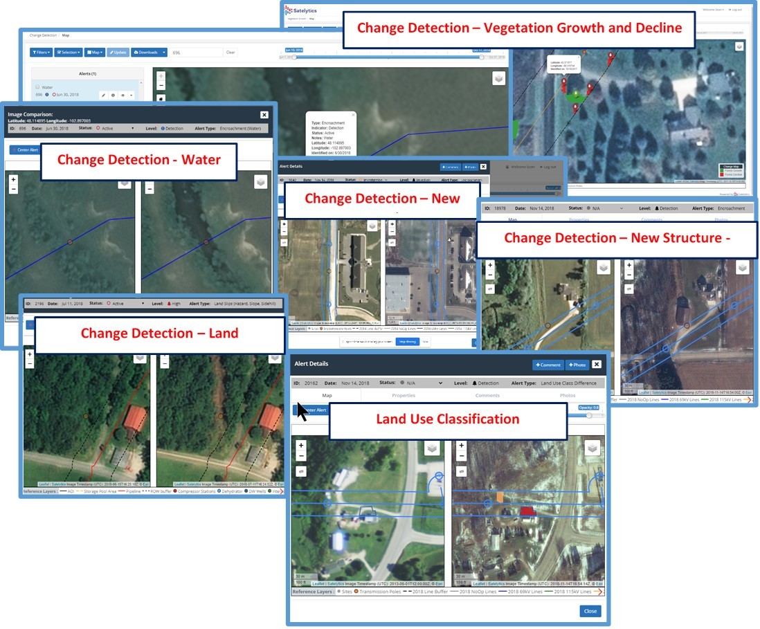
Satelytics' AI-powered software analyzes every pixel, every time. Our geospatial analytics performed on tasked high resolution imagery allows very precise and timely alerts for events, including encroachments in our customers' infrastructure. Satelytics’ customers are interested in minimizing threats and consequences in urban, rural, mountainous, and marine geographies.
In the industries we serve, it’s critical to understand land use — and often a requirement for periodic classification of that use to better comprehend risk. This information is widely used to help operations personnel understand and manage risk, while planning inspections of vital infrastructure. Our utility and pipeline customers use classifications like water, soil, vegetation, urban, agriculture, and more, to map their assets and manage risk. This includes the assignment of threat levels and identifying high consequence areas in their infrastructure. Our cloud portal, satelytics.io, alerts field teams via text and email, and can send data directly to your company's preferred software system and generate work orders for:
Real examples!
Satelytics' encroachment and land classification change detection can even be tied back to property records to increase efficiencies. Our AI-powered analytics never rest — and don’t make mistakes. NO HUMAN ERROR, NO ROUTINE MONITORING! Every pixel is analyzed for any number of business challenges, every time, meaning costs can be shared across multiple user groups. Satelytics for the non-connected world even provides our full capabilities in areas where cellular and internet coverage is scarce.

Examples of Satelytics for the non-connected world.
Satelytics Inc., www.satelytics.com, is a cloud-based geospatial analytics software suite. Multispectral and hyperspectral imagery is gathered from satellites, UAV, planes, and fixed cameras, and processed to provide both alerts and qualitative results for our customers. Data can be gathered up to a daily basis, and results are sent to customers within hours. This includes the specific problem, location, magnitude, and even qualitative information, which minimizes cost, impact, and operational disruption for our clients.
Toledo, OH – September 14, 2020. For more information, contact David Dunham, ddunham@satelytics.com, (o) (419) 728 0060 extension #101, (c) (701) 213 0294.
We use cookies to analyze our web traffic and to enhance your experience. By continuing to view this website, you agree to our use of cookies.
Our Privacy Policy