
• General
• General

The DailyMail.com published an article warning beachgoers to watch out for toxic algal blooms. Here are the details and a graphic from the article outlining the concerning trend:
(credit: Stacy Liberatore, https://www.dailymail.co.uk/sciencetech/article-8691657/Over-300-bodies-water-plagued-algae-blooms-year.html)

My family and I are heading to the lake this Labor Day weekend. Generations of our family have been going to Bad Medicine Lake in northern Minnesota since the 1920s. This deep, spring-fed lake is one of the cleanest in the state — with clarity to 25 feet — shown to the left from our swim dock! Due to its cool northern location and sand filtered watershed, toxic algal blooms at Bad Medicine are non-existent. However, in other parts of the state and across North America, blooms are plentiful.
Satelytics' science allows for early detection of nutrient loading, which is the primary driver of harmful algal blooms. We measure every pixel, every time — down to ½ m2, over an entire body of water or watershed area for phosphorous, phycocyanin, and chlorophyll-a, all in parts per billion (PPB) concentration! Our measurement algorithms are fully ground truthed and guaranteed accurate to a few PPB for any watershed area, anywhere in the world. No more single point sampling and trying to extrapolate what is happening in your tributary or reservoir; you get the entire picture with Satelytics.

satelytics.io examples. Every pixel, every time.
With this data our customers are TAKING action — NOT REACTING — in targeted areas of a watershed before algal blooms consume a lake. Our customers have used our analytics to identify sources of phosphorous runoff from agriculture, urban contamination, and even broken septic systems, before their reservoirs became compromised. They even use Satelytics' water quality tools to ensure remediation actions are effective after the initial bloom is identified. And if your environment is in a remote area with low connectivity, all data is still accessible through Satelytics for the non-connected world, our mobile platform.
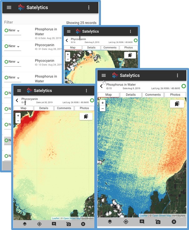
Satelytics for the non-connected world water quality examples.
Satelytics' water quality measurements include:
Satelytics has assisted with water quality projects across the globe.
“Prior to your analysis we were restricted to photo-points on the ground. Your results allowed us a lake-wide perspective. Your analysis contributed to our assessment and communications that the water quality of Lake Britton was improved by our deep-water release.” - Edward Cheslak, Senior Consulting Scientist at a major western power utility company
“Satelytics' invaluable analysis of satellite imagery helps us ensure that we are confident in the results. It’s a huge cost savings in comparison to field testing or comparable modelling.” - Robin Richards, Principal at Ramboll
Use Satelytics and keep your water pure...like Bad Medicine Lake! Have a wonderful and safe Labor Day weekend with friends and family.
Satelytics Inc., www.satelytics.com, is a cloud-based geospatial analytics software suite. Multispectral and hyperspectral imagery is gathered from satellites, UAV, planes, and fixed cameras, and processed to provide both alerts and qualitative results for our customers. Data can be gathered up to a daily basis, and results are sent to customers within hours. This includes the specific problem, location, magnitude, and even qualitative information, which minimizes cost, impact, and operational disruption for our clients.
Toledo, OH – September 4, 2020. For more information, contact David Dunham, ddunham@satelytics.com, (o) (419) 728 0060 extension #101, (c) (701) 213 0294.
We use cookies to analyze our web traffic and to enhance your experience. By continuing to view this website, you agree to our use of cookies.
Our Privacy Policy