
• Oil & Gas,Electric & Gas Utilities,Water & Wastewater,Pipeline Operators,Mining & Extraction
• Oil & Gas,Electric & Gas Utilities,Water & Wastewater,Pipeline Operators,Mining & Extraction
Of utmost importance to the accuracy of our calculations is the incorporation of data on local meteorological conditions. These meteorological conditions need to be highly specific to the leak area because they have a direct impact on the dispersion of the leaked methane.
Allan Adams, Chief Scientist at Satelytics
We’re not spilling all our secrets about our recipe for measuring methane plumes, but there are a few key ingredients we need our customers to bring to the table to ensure the results are as accurate as possible. Satelytics is dedicated to using satellite imagery with the highest possible spatial resolution to calculate the source location and flow rate of methane leaks at the source.
Wind direction clearly dictates where the methane is heading, but reporting the wind speed is equally important. Strong winds will cause plumes to be less concentrated and more dispersed. Light winds create the opposite effect. It is important to note that very local wind conditions can vary greatly from those found even a mile away. According to Allan Adams, Satelytics' Chief Scientist, “Without wind data specific to that site, calculating flow rates is impossible.”
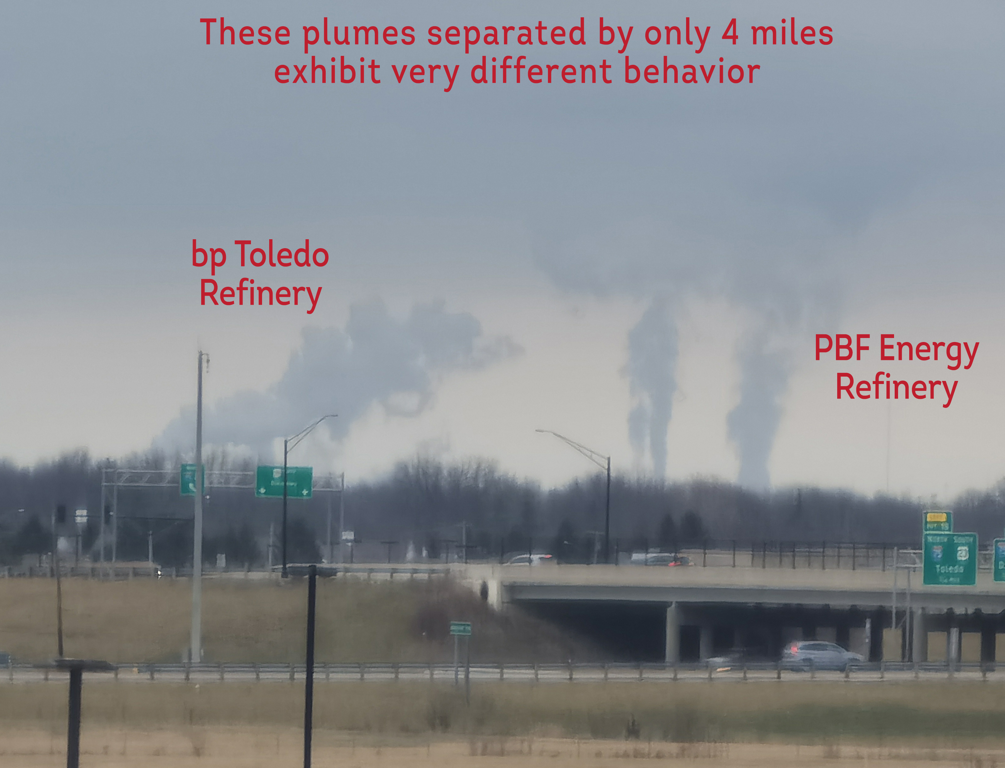
Very local winds affect plume behaviors.
Similarly, local temperatures and humidity levels affect properties of methane plumes. Heat causes plumes to spread more, while cold air conditions cause them to be more concentrated.
Lastly, atmospheric inversions play a key role in characterizing and measuring methane plumes. Inversions can either limit or exaggerate plume vertical movement, depending upon the specific stratification present in the atmosphere.
With the collected satellite imagery, Satelytics’ software, and local meteorological conditions — wind direction and speed, temperature, humidity, and a profile of local atmospheric inversions — we can pinpoint the source of the leak and accurately calculate the flow rate of the leak and the concentrations in parts per million (ppm).
Having the ability to rapidly detect and measure leaks after they start allows Satelytics to alert our customers while incidents are smaller and more easily fixed — a feat achieved through expansive satellite coverage and more frequent image capture revisit times. As a result, numerous consequences such as staff safety risks, fines, and exposing the public to potentially hazardous conditions created by methane, can be minimized. Field crews can also be effectively dispatched to exact locations rather than searching for the proverbial needle in a haystack. Additionally, any methane incident — large or small — and its details will be kept on record in case facts or reports need to be produced for insurance, legal, or regulatory purposes.
With inexpensive local weather data, Satelytics can ensure that your company can act on accurate and timely measurement of methane emissions.
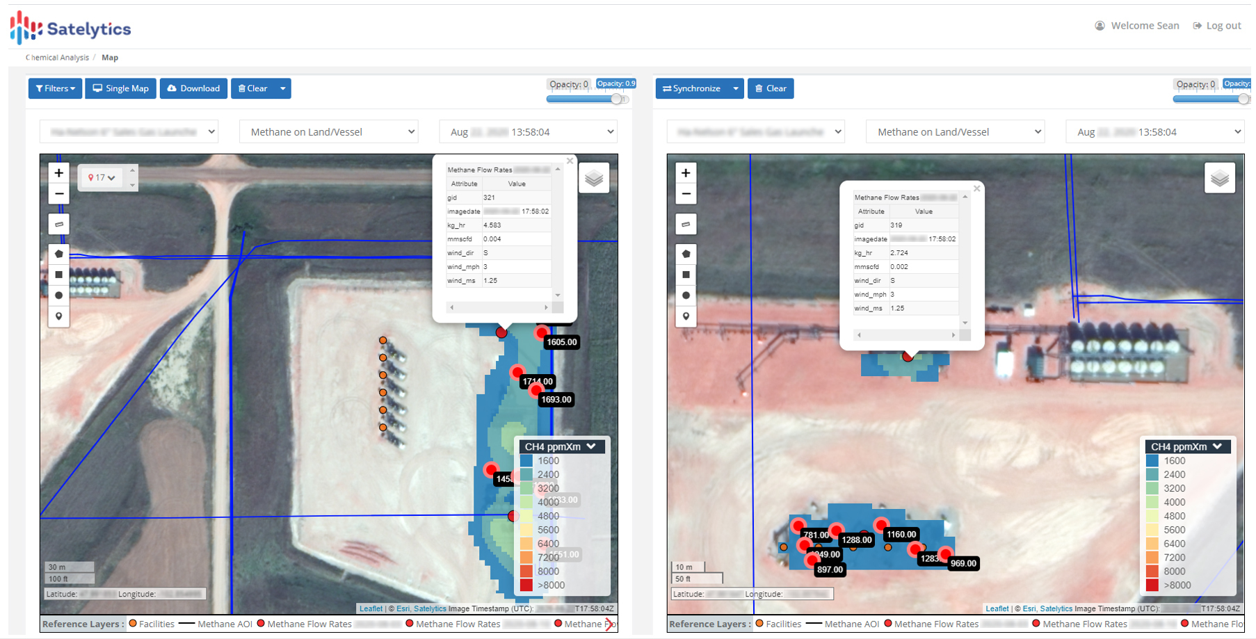
Methane measurements — source, flow rate, and concentration (ppm).
We use cookies to analyze our web traffic and to enhance your experience. By continuing to view this website, you agree to our use of cookies.
Our Privacy Policy