
• Oil & Gas,Electric & Gas Utilities,Pipeline Operators,Mining & Extraction
• Oil & Gas,Electric & Gas Utilities,Pipeline Operators,Mining & Extraction
I am nearsighted. The technical term for this is myopia. Being myopic means that I can see objects up close clearly but objects at a distance remain blurry. I have worn eyeglasses since the 5th grade. By putting a lens in front of my eyes, the light streaming in is refocused, making the blurry clear.
The Wall Street Journal recently published a good article focused on satellite surveillance for methane emissions. Satelytics is data agnostic, meaning that we process data from any acceptable source. Most of our projects utilize satellite data because satellites offer the best platform for monitoring large asset areas, which was addressed well in the article. The head of the French national space agency was quoted as saying “Satellites are the best tool,” because “They cover all the world in a few days.” BINGO! this is spot on and is why our methane customers keep coming back with ever-larger areas to survey.
Now back to myopia and the usefulness of a lens to clarify what is happening in the distance.
A satellite is just an expensive piece of metal without a good sensor on board. The sensor measures light reflectance at a resolution determined by the manufacturer. High spatial resolution yields more detail and a clearer view of the earth’s surface. The spatial resolution offered by many methane-focused satellites today is typically in the range of 30-400 meters, but some are as coarse as several thousand meters.
It simply is not possible to detect objects or sources that are smaller than the resolution of the sensor. What small plumes are being missed with coarse resolution satellite data? What is the usefulness of the dataset if it isn’t actionable? A large methane plume may exist but if its source is not identifiable, how can you act on it? Just like I can’t see street signs at distance and decide where to turn next, low-resolution data is not actionable.

Specificity enables problem resolution.
Satelytics’ methane algorithm analyzes 3.7-m spatial resolution commercial satellite data, which allows us to specify the source of the leak within 4 meters. No other company comes close to this type of specificity. If a wellhead is leaking it is identifiable. When a tank is venting, it can be seen.
And it’s not just detection — with Satelytics, volume is quantified as well. Methane flowrate has been verified by our customers at sites all over the world in both upstream oil and gas and urban natural gas distribution infrastructure.
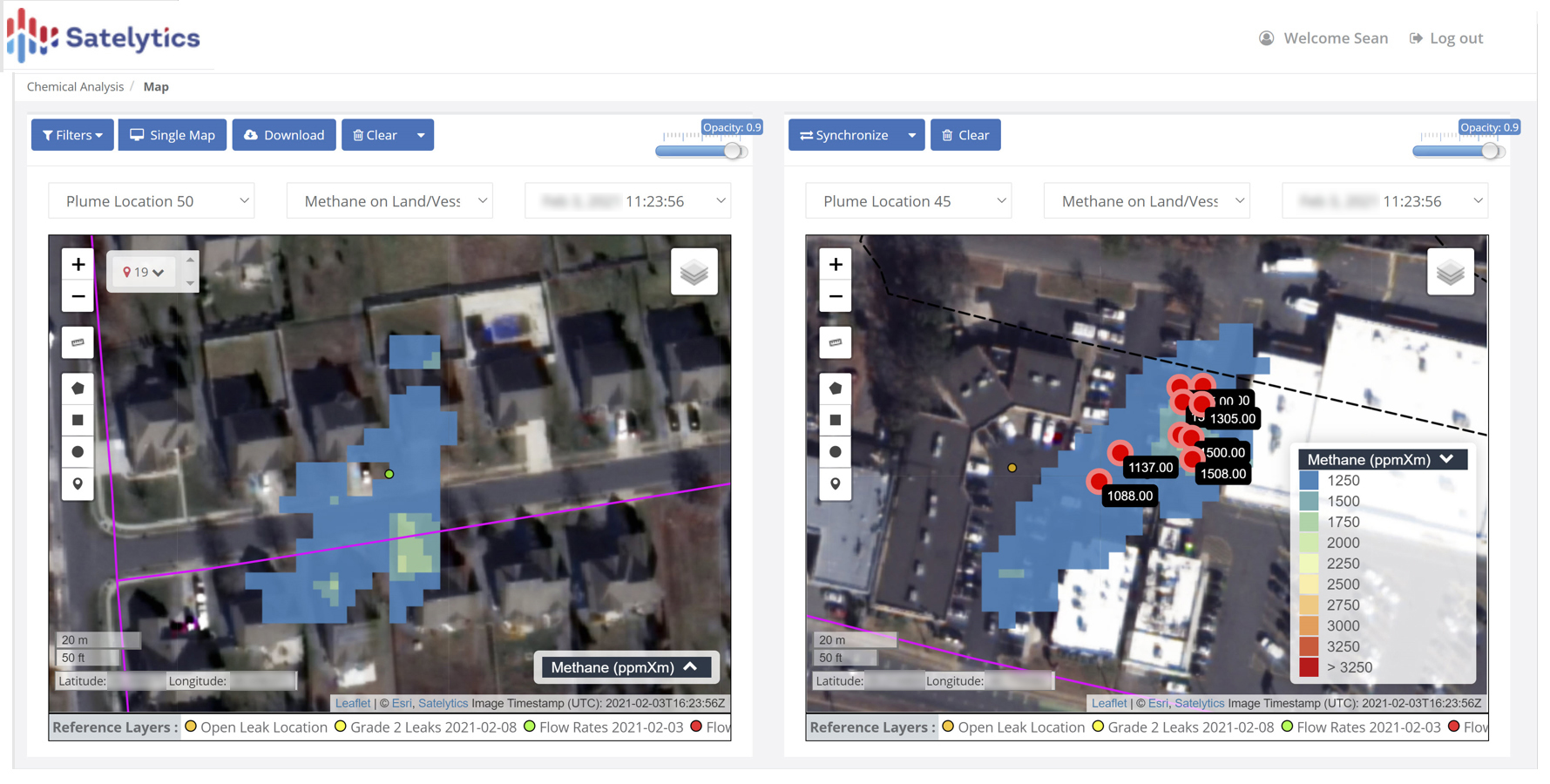
Measurement of urban natural gas leaks.
Make your methane data go to work for you by directing response personnel directly to the source needing attention. Use that data again for reporting volumes as they are reduced through operational efficiencies!
Maximize ROI on your investment by also employing any of 40 other measurements that can all be obtained from the same set of satellite imagery including liquid hydrocarbon leaks, brine leaks, vegetation management, encroachments, geohazards, and more. All our data processing occurs on the cloud and analytical results are delivered in a matter of hours after satellite overpass.

Maximize your ROI by measuring more than just methane.
Satelytics’ customers aren’t myopic. They use the best data sources to clearly achieve true operational successes.
We use cookies to analyze our web traffic and to enhance your experience. By continuing to view this website, you agree to our use of cookies.
Our Privacy Policy