Problem: Poor understanding of capabilities of geospatial analytics.
Solution: Consider these questions.
Benefit: Adoption of powerful solutions.
“Write down the problem and draw a diagram.” This is the phrase I heard over and over again from my father when he helped me with my math and science homework in middle and high school. Break the problem into small, understandable pieces, then the solution often finds itself. He earned a mathematics degree in college and has a very analytical and process-oriented mind.
The field of geospatial analytics is still relatively new for most people and companies. When I arrange an introductory meeting and show real Satelytics project examples (no PowerPoint slides!), people often say something like, “I had no idea you could do that,” or, “That is incredible!”
If your company is exploring what geospatial analytics can provide, here are some questions to consider before you start:
What information are you seeking?
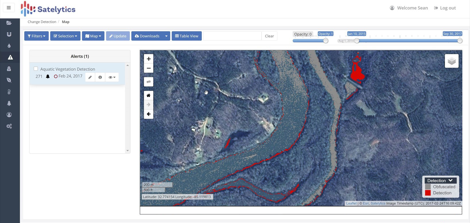
Our watershed customers' interests include water quality, nutrient load sources, and sediment loading. For physical condition of reservoirs, the interests could be shoreline erosions, construction of illegal docks, or subsurface and emergent vegetation.
Alerts on illegal construction.
How big is the feature of interest?
Perhaps seasonal runoff has exacerbated sediment loading into reservoirs or agricultural runoff is threatening to cause harmful algal blooms. In these instances, the size of a water body or tributary determines the spatial resolution of imagery that must be used. For large water bodies, 30-meter resolution is acceptable to determine the source of nutrient load. If a creek or stream is to be analyzed, then 3 meters or less pixel size may be necessary.
In the use cases of locating illegal construction, change detection, or vegetation in the watershed, we require pixel sizes of 0.5 meters or less.
With Satelytics' water quality measurements, every pixel is analyzed every time over the entirety of the watershed area.
Where are you looking?
High-resolution satellite imagery is sold in 100 square kilometer blocks called tiles. Specifying a precise area of interest allows us to minimize the data costs you incur. Don’t buy data you don’t need!
How often do you want to inspect the area of interest?
The sooner the threat is identified, the lesser the risk and cleanup become. Today, satellite revisit frequencies are daily. The amount of information generated and the cost of the data are considerations to be balanced.
For water quality monitoring, our customers often choose quarterly frequencies to coincide with seasonal changes. We are often asked to respond with additional monitoring to coincide with upsets in the system due to natural or human-caused events
Identification of hydrilla.
Can it be quantified?
This is the big question and usually means physical measurements of concentration or rate of the factor of interest. Physical measurements could include the size of erosion down to the square foot or the spread of sediment load across a lake or river.
For our water quality measurements, we quantify in parts per billion constituents like phosphorous, nitrogen, chlorophyll-a, phycocyanin, and heavy metals. From that same set of data, Satelytics' algorithms are also able to provide quantifications for turbidity, total suspended solids, temperature, and soon PFAS!
Phycocyanin vs. phosphorus concentrations.
How long does it take to get the results?
Geospatial analytics can provide useful alerts on the condition of large asset areas if that information is delivered in a timely manner. Our Constant Vigilance™ algorithms process large data sets with results ready for viewing or downloadable in a matter of hours after imagery is gathered. Current Satelytics customers have chosen our tools after becoming frustrated with long lead times, months sometimes, that have accompanied previous analytics companies and Lidar-based tools.
The field of geospatial analytics is in its infancy. Satelytics is the market leader, with nearly 700 trillion pixels analyzed to date. We can help you if you define the problem you are trying to solve before you start looking for solutions.
Interested in our newsletter?
This site uses cookies
We use cookies to analyze our web traffic and to enhance your experience. By continuing to view this website, you agree to our use of cookies.