Problem: Poor understanding of capabilities of geospatial analytics.
Solution: Consider these questions.
Benefit: Adoption of powerful solutions.
“Write down the problem and draw a diagram.” This is the phrase I heard over and over again from my father when he helped me with my math and science homework in middle and high school. Break the problem into small, understandable pieces, then the solution often finds itself. He earned a mathematics degree in college and has a very analytical and process-oriented mind.
The field of geospatial analytics is still relatively new for most people and companies. When I arrange an introductory meeting and show real Satelytics project examples (no PowerPoint slides!), people often say something like, “I had no idea you could do that,” or, “That is incredible!”
If your company is exploring what geospatial analytics can provide, here are some questions to consider before you start:
What information are you seeking?
Specialty chemical industry professionals have expressed to us interests that include water quality, emissions, heavy metals, and site remediation. As the push to decarbonize continues to grow, specialty chemical companies are also looking for analytics to support carbon uptake, forestation projects, and regenerative agriculture.
Forestry analytics for carbon management.
How big is the feature of interest?
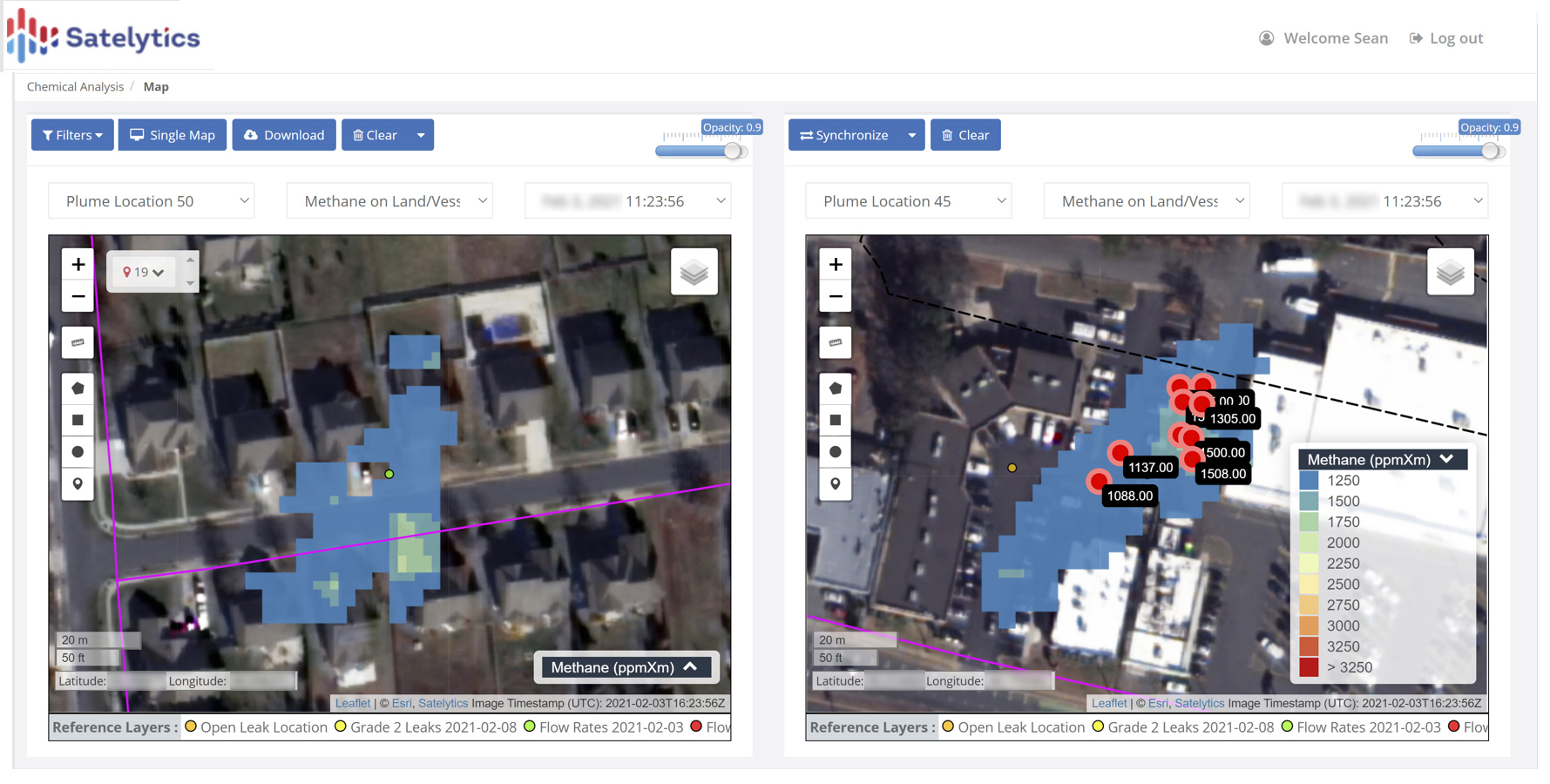
Satelytics currently provides to chemical industry partners analyses and alerts focused on water quality; remediation of heavy metals; the presence of hydrocarbons; and thermal measurements for sites, plant holding ponds, and effluents to lakes and rivers. The size of the water body or site dictates the resolution to be used for the analyses and can range from 30-meter pixels down to 0.5-meter pixels. For air emissions, the spatial resolution must be able to identify leak sources for specific pieces of equipment or plant features.
Methane emissions and quantification.
Where are you looking?
High-resolution satellite imagery is sold in 100 square kilometer blocks called tiles. Specifying a precise area of interest allows us to minimize the data costs you incur. Don’t buy data you don’t need!
How often do you want to inspect the area of interest?
The sooner the threat is identified, the lesser the risk and cleanup become. Today, satellite revisit frequencies are daily. The amount of information generated and the cost of the data are considerations to be balanced.
For water quality monitoring, our customers often choose quarterly frequencies to coincide with seasonal changes or changes in plant operations. For the chemical industry, geospatial analytics can also provide a look back in time for litigation and remediation concerns through analysis of archival satellite imagery which dates back to the early 1980s.
Can it be quantified?
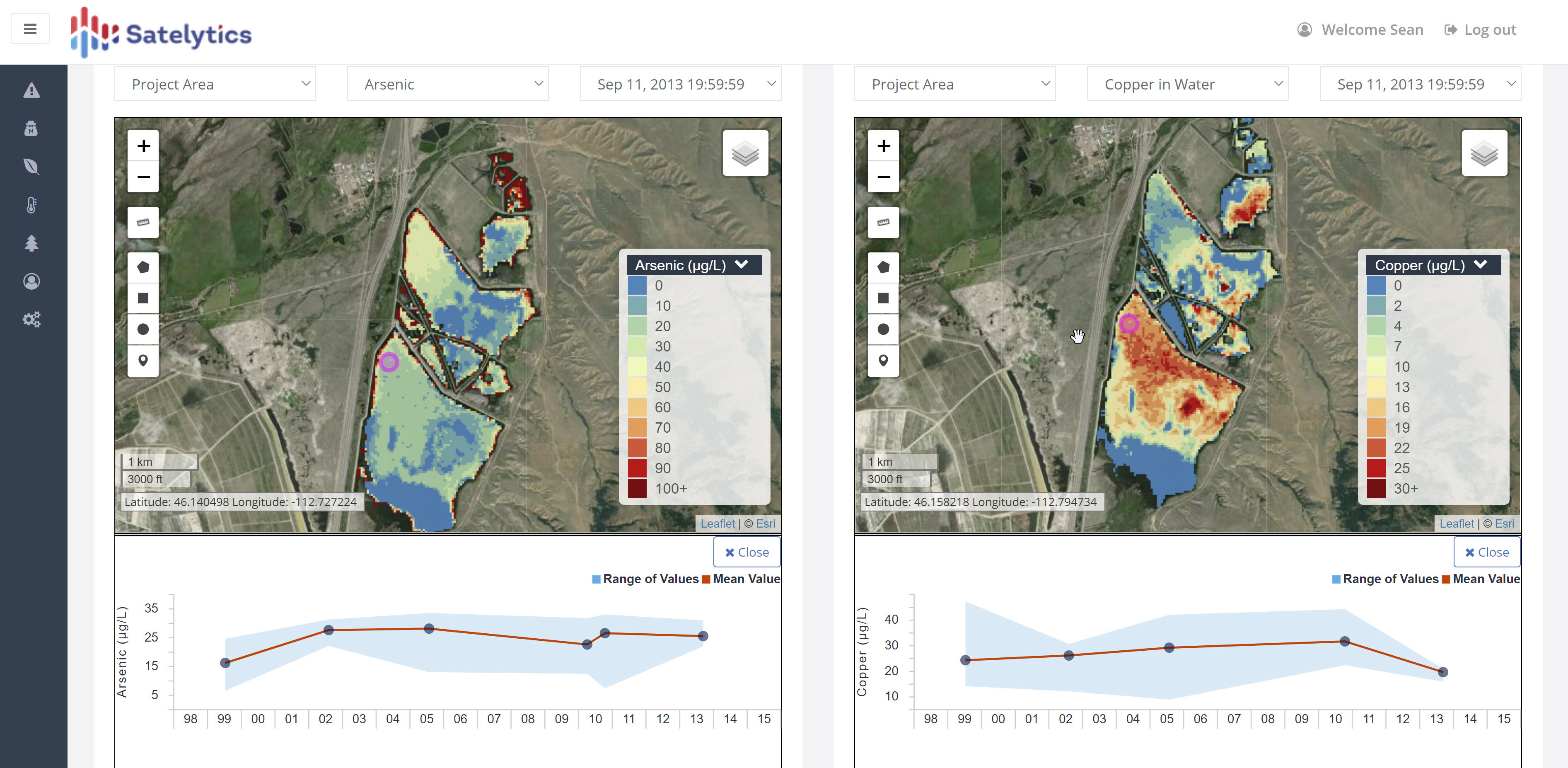
This is the big question and usually means physical measurements of concentration or rate of the factor of interest. Physical measurements could include changes in areas of a remediation site and condition of vegetative cover. For water quality measurements, we quantify in parts per billion constituents like phosphorous, nitrogen, chlorophyll-a, phycocyanin, and heavy metals.
From that same set of data, Satelytics' algorithms are also able to provide quantifications for turbidity, TSS, temperature, and soon PFAS. Air emissions of methane are quantifiable, including concentration and flow rate. As satellite data sources continue to increase, future analytics are expected to include gas speciation!
Quantification of heavy metals.
How long does it take to get the results?
Geospatial analytics can provide useful alerts on the condition of large asset areas, if that information is delivered in a timely manner. Our Constant Vigilance™ algorithms process large data sets with results ready for viewing or downloadable in a matter of hours after imagery is gathered. Current Satelytics customers have chosen our tools after becoming frustrated with long lead times (sometimes months) that have accompanied previous analytics companies and LiDAR-based tools.
The field of geospatial analytics is in its infancy. Satelytics is the market leader, with nearly 700 trillion pixels analyzed to date. We can help you if you define the problem you are trying to solve before you start looking for solutions
Interested in our newsletter?
This site uses cookies
We use cookies to analyze our web traffic and to enhance your experience. By continuing to view this website, you agree to our use of cookies.