• General

• General
In the unforgiving arena of infrastructure protection, a single point of failure can cascade into catastrophic consequences. The U.S. Department of Energy estimates that power outages alone cost the American economy $150 billion annually, while global economic losses from water pipeline leaks amount to $14 billion per year. These staggering figures underscore a critical truth: traditional single-solution approaches are failing to protect our most vital assets.
When organizations rely exclusively on one monitoring method — whether ground-based sensors, scheduled inspections, or basic satellite imagery — they create dangerous blind spots that sophisticated threats eagerly exploit. This approach is analogous to defending a fortress with only one wall: impressive until an attacker finds the inevitable weakness.
Defense-in-Depth, a time-tested military strategy, acknowledges that no single defensive measure is impregnable. Instead of concentrating all resources at a single point, this approach deploys multiple layers of protection that create mutually reinforcing barriers.
The principle is elegantly simple: when attackers breach the first line of defense, they encounter successive layers that progressively weaken their advance, ultimately exhausting their resources before reaching critical assets. In infrastructure monitoring, this translates to layering complementary technologies that address each other's limitations while maximizing overall threat detection capabilities.
At Satelytics, we position satellite-based geospatial analytics as the cornerstone of an effective Defense-in-Depth strategy. This isn't corporate hyperbole; it's supported by compelling operational data that demonstrates why satellite technology deserves the strategic high ground in your defensive architecture.
Comprehensive Coverage at Scale. Satellite technology delivers unmatched territorial coverage with remarkable efficiency. Our systems can monitor vast multi-state areas and address more than 90% of potential threats across entire infrastructure networks. This broad-spectrum capability provides the foundational intelligence layer that guides more targeted ground-based interventions.
The economics are equally compelling. While traditional LiDAR systems cost $100-120 per mile, satellite-based monitoring can cover the same area for approximately $15 per mile — an 87.5% cost reduction that frees resources for complementary monitoring technologies.
Rapid Response Capabilities. Speed matters in threat detection. Where traditional inspection methods require weeks or months to complete comprehensive assessments, satellite-based systems deliver actionable intelligence within hours. This temporal advantage is crucial when dealing with rapidly evolving threats like methane leaks, vegetation encroachment, or pipeline integrity issues.
Precision-Guided Efficiency. Perhaps most importantly, satellite analytics optimize resource allocation by highlighting the 5-10% of infrastructure networks where problems are most likely to occur. This precision dramatically reduces the scope of ground-based investigations, allowing specialized teams to focus their efforts where they'll have maximum impact.
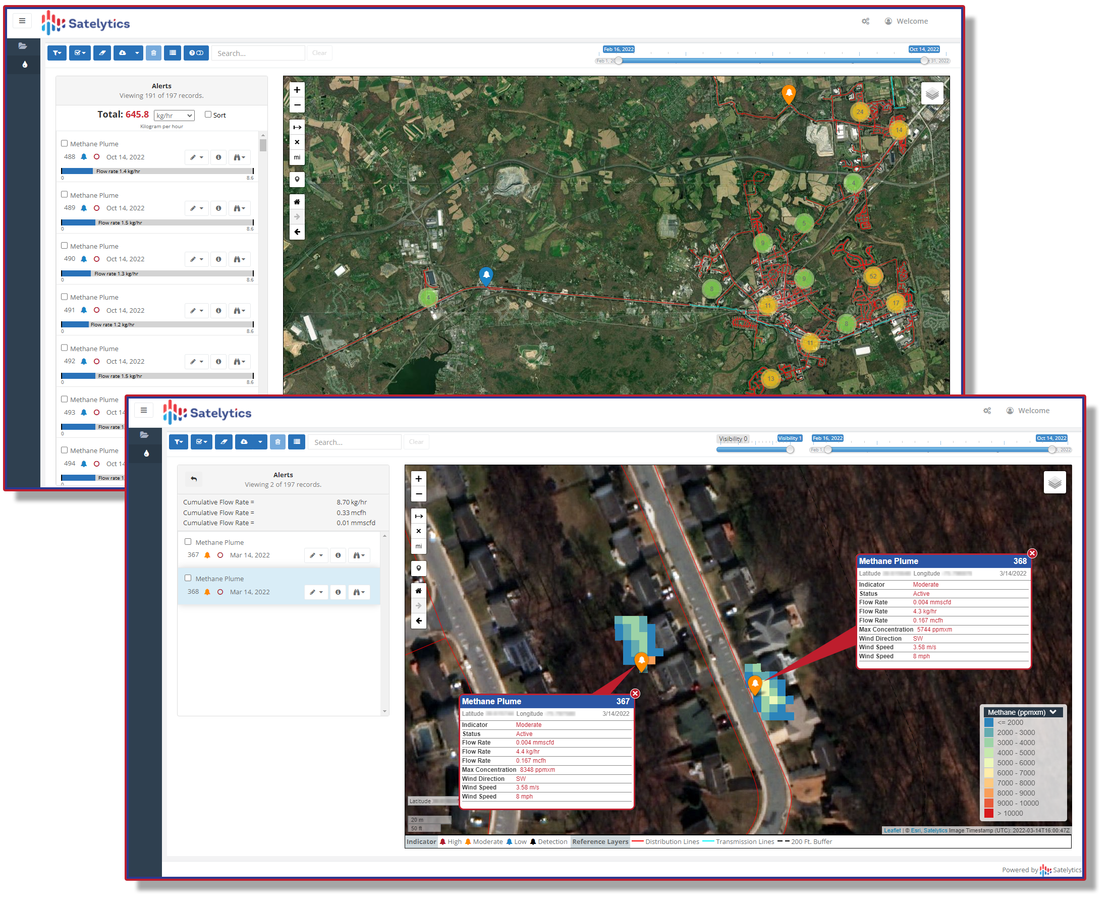
Methane Measurement Over Gas Distribution Networks
The methane measurement challenge perfectly illustrates Defense-in-Depth principles in action:
This three-layer approach leverages each technology's strengths while compensating for individual limitations, creating a monitoring network that no single technology could achieve independently.

Methane measurement.
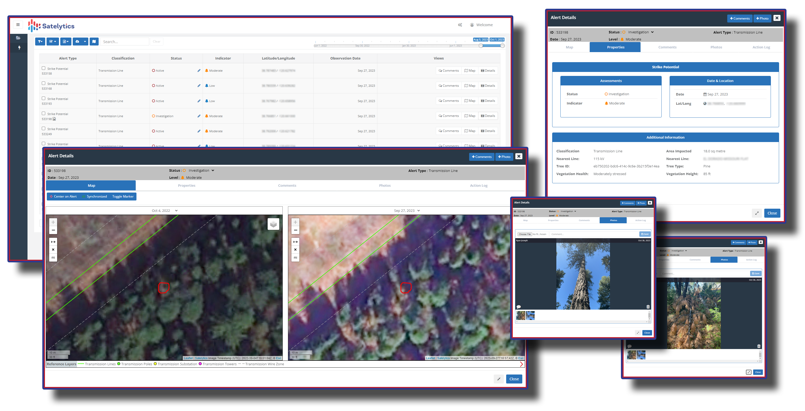
Vegetation Management: Preventing the Leading Cause of Outages
Vegetation-related issues cause 25% of all utility outages, with trees responsible for 92% of weather-related power outages. The financial impact is staggering: utilities spend $6-8 billion annually on vegetation management, while vegetation-related outages cost billions more in lost productivity and emergency response.

Utility vegetation management.
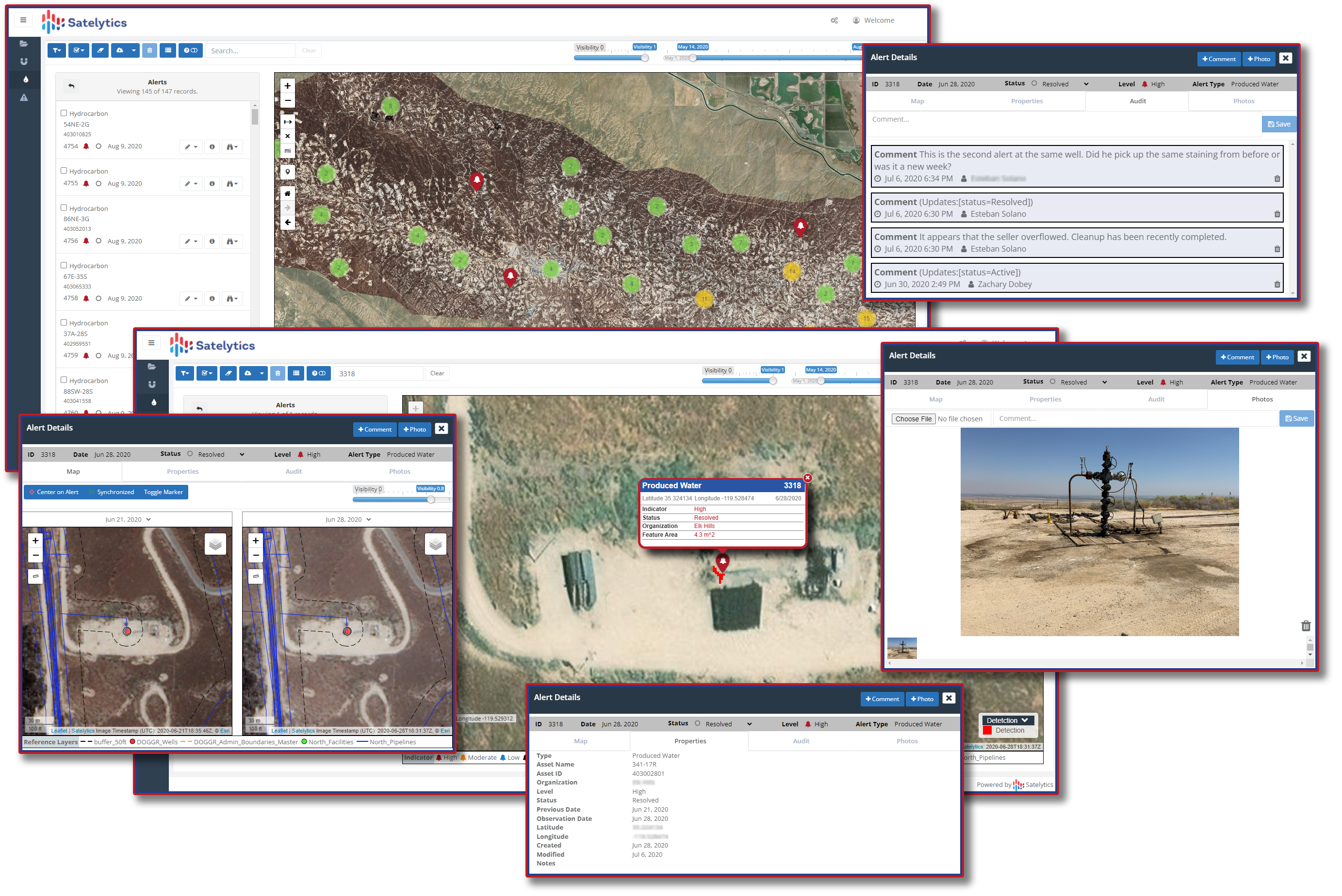
Liquid Pipeline Leak Detection: Catching the "Drip-Drip-Drip"
Pipeline leak detection represents a $3 billion annual industry expenditure, yet traditional internal monitoring systems often miss smaller leaks that compound into major problems over time. The Defense-in-Depth approach addresses this critical gap:

Produced water leak detection.
The Defense-in-Depth approach delivers benefits that extend far beyond immediate cost reductions:
Skeptics might argue that Defense-in-Depth creates operational complexity. However, modern satellite systems integrate seamlessly with existing Geographic Information Systems (GIS) and asset management platforms. This integration provides comprehensive infrastructure intelligence that supports long-term strategic planning while optimizing short-term operational decisions.
The key insight is that satellite technology doesn't replace existing monitoring systems; it enhances them by providing the strategic intelligence layer that maximizes their effectiveness. Ground-based sensors, inspection teams, and specialized equipment remain essential, but satellite guidance ensures they're deployed where they'll have maximum impact.
The Defense-in-Depth approach isn't just technically superior, it's economically essential. With aging infrastructure requiring $2.6 trillion in upgrades in the U.S. alone, and pipeline upgrade costs projected at $300 billion over the next decade, organizations cannot afford inefficient monitoring approaches that waste resources on unfocused inspections.
Satellite-based systems enable data-driven resource allocation that maximizes return on infrastructure investments. By identifying the 20% of network segments where most problems occur, organizations can prioritize upgrade and maintenance spending where it will have the greatest impact.
In today's complex threat landscape, single-layer defenses are inadequate for protecting critical infrastructure. The converging pressures of aging systems, extreme weather events, and resource constraints demand smarter approaches that leverage the strengths of multiple monitoring technologies.
Defense-in-Depth, anchored by satellite-based geospatial analytics, provides the strategic framework for building truly resilient infrastructure monitoring systems. By acknowledging that each monitoring approach has limitations while maximizing their collective strengths, organizations can achieve comprehensive protection that no single technology could provide.
The evidence is clear: satellite technology delivers the comprehensive coverage, rapid response capabilities, and cost-effectiveness that make it the logical cornerstone of a modern Defense-in-Depth strategy. The question isn't whether your organization can afford to implement satellite-based monitoring; it's whether you can afford not to.
Ready to strengthen your infrastructure defense strategy? Call us to discover how satellite-based geospatial analytics can provide the strategic intelligence layer that transforms your entire monitoring approach from reactive to predictive, from expensive to efficient, and from vulnerable to resilient.