• Electric & Gas Utilities

• Electric & Gas Utilities
Wild-weather fire seasons and tightening regulations are forcing utilities to clear wider rights-of-way (ROWs) than ever. One West Coast transmission owner just sank more than US $30 million into brushing and tree-felling after its regulator added five feet of clearance on each side of 2,100 line-miles. The capital is spent; now the real work begins—keeping those corridors clear, season after season, without ballooning O&M.
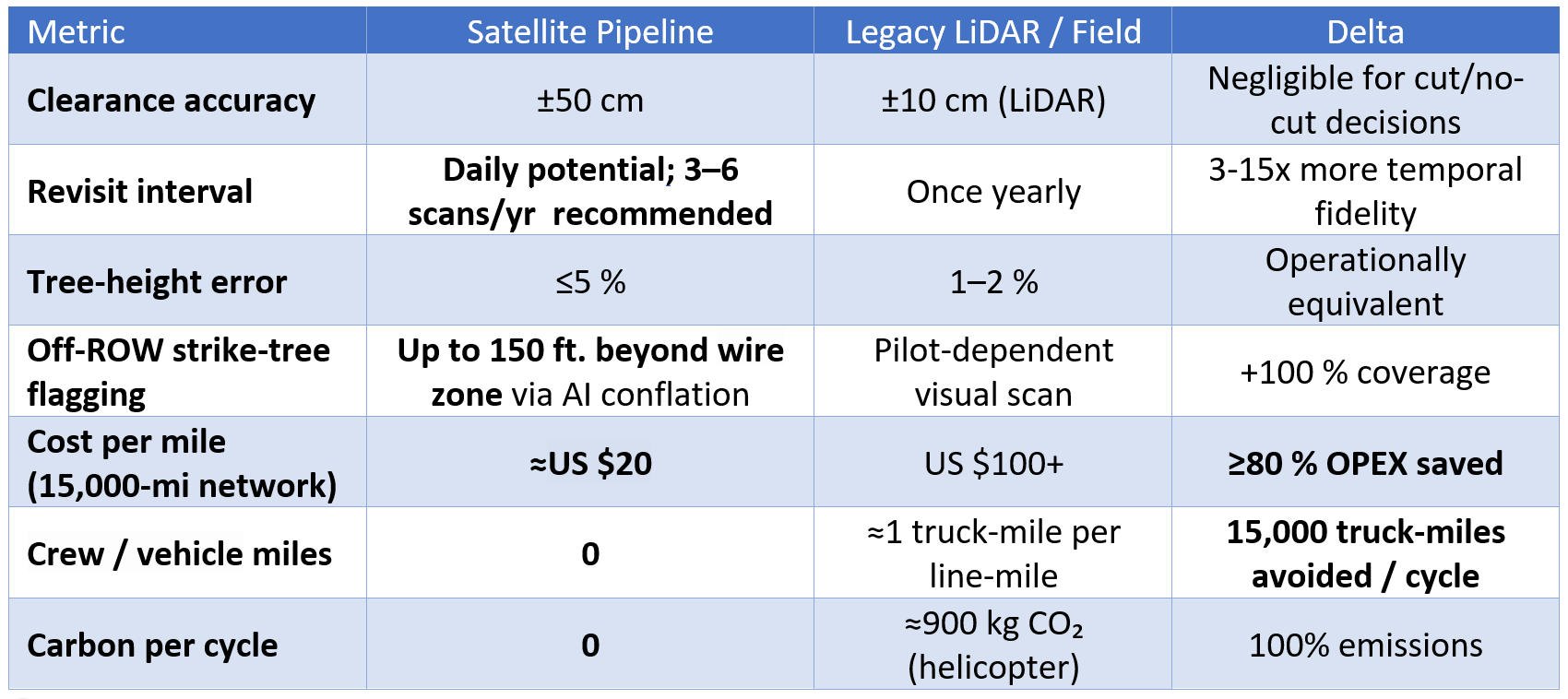
Helicopter or fixed-wing LiDAR flyovers remain the default for many utilities, but the numbers no longer pencil out:
Ground crews and UAVs close some gaps but create others: vehicle mileage, road-access delays, and the 30–50 fatalities per 100,000 U.S. line workers every year keep pressure on safety and insurance budgets.
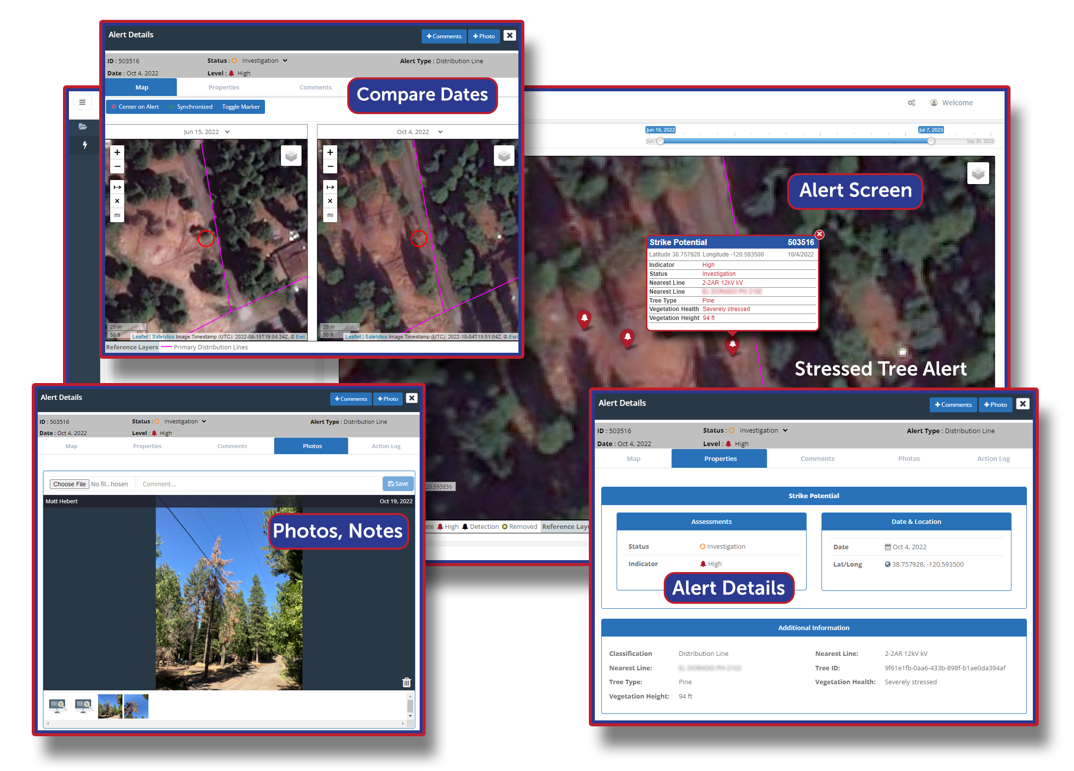
Commercial very-high-resolution constellations such as WorldView Legion and Airbus Pléiades NEO (both with a spatial resolution of 30 cm and daily revisits) deliver near-infrared imagery and stereo options that enable Satelytics to calculate canopy height with sub-meter accuracy. Satelytics turns those pixels into decisions:


Strike potential alerts direct immediate, precise action.
LiDAR advocates highlight 4-inch resolution. What matters in 2025 is frequency and context. Satellites deliver 12-inch resolution. Combine that with five decades of historical imagery and you obtain growth curves, drought stress indices, and strike-probability models that no annual LiDAR snapshot can match.
LiDAR Narrative: "LiDAR is the gold standard for clearance."
Reality: True, for millimetric design tolerances. For hazard-tree triage, ±50 cm is sufficient. Conductor-clash probability models peg wind speed and span length as the dominant ignition drivers, not ±10 cm of bark.
LiDAR Narrative: "We need sub-decimeter data for regulators."
Reality: Regulators care about risk reduction and audit trails. Satellite pipelines export tree-level polygons with time-stamped height, species, and health attributes — digitally signed and immutable — satisfying NERC auditors while slashing cost.
LiDAR Narrative: "Aircraft give us thermal, UV, and multi-sensor stacks."
Reality: So do satellites. Near-infrared bands help us quantify chlorophyll; SAR flags moisture-stressed snags day or night; thermal infrared payloads on upcoming constellations will layer in surface-temperature anomalies for early fire detection.
LiDAR Narrative: "Ground crews validate what cameras miss."
Reality: Precisely — so let's deploy them only where our AI flags anomalies, reserving limited forester hours for the 2-3% of spans with actionable risk. Avista's 2024 PUC filing already prices satellite tiers to scale down to US $18 per mile when mileage >1,000.
Treatment Efficacy: Satellite analytics don't stop at detection. By overlaying herbicide application records and contractor-machine logs, utilities can verify that vendors hit every span, detect misapplications within 24 h, and correlate vegetation health and species with treatment efficacy.
Safety ROI: Eliminating 15,000 truck-miles and all rotor-hours removes high-severity exposure, directly lowering workers comp premiums that run US $10,000 per field employee per year in high-risk profiles.
Carbon Accounting: A utility pledging Net Zero scope-3 emissions can bank ≈1,400 t CO2e avoided over a five-year vegetation cycle — enough to offset the full annual footprint of its headquarters campus.
Capital Efficiency: Every dollar not burned on aerial surveys is a dollar left for grid-hardening. PG&E's own bow-tie analysis shows vegetation programs rival covered-conductor programs for risk-buy-down when costs are contained.
Wildfires don't wait for flight windows, and regulators no longer accept anecdotal patrols. Satelytics delivers tree-level intelligence across your entire service territory within hours of satellite overpass, letting you redirect crews, document compliance, and defend rate-case expenditures with a spreadsheet, not a PowerPoint.
The corridor is clear. Keep it that way — from orbit.

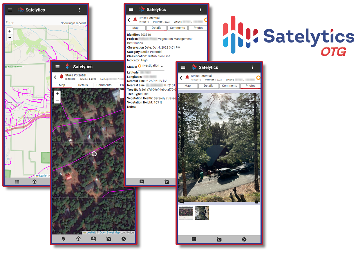
Satelytics OTG™ helps your team carry critical data into the field, and back to the office.