Using Satellite Imagery and Satelytics for Vegetation Management within Pipelines and Electrical Transmission Line Right-of-Ways
The electric grid, one of the greatest engineering achievements in modern history, is critical to our national economy and way of life. This is a complex system that began as small neighborhood power stations serving local needs, that grew into a multi-million mile connected network distributing power far from where it was generated.
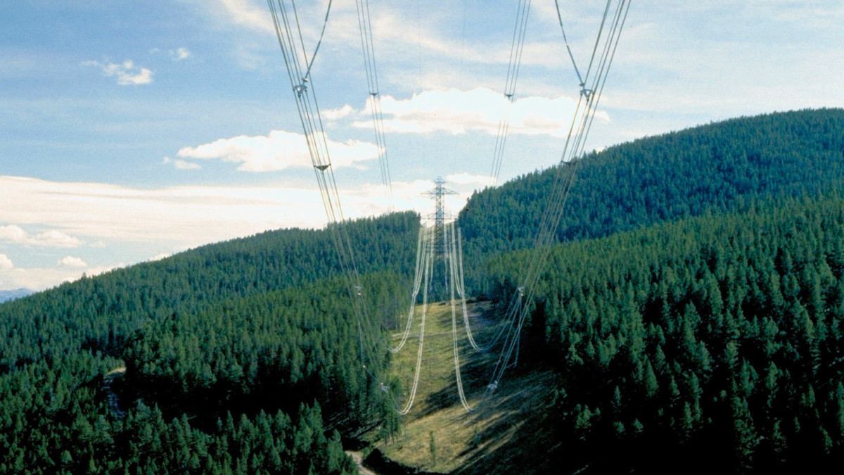
There are two segments in an electric delivery system: transmission and distribution. Distribution lines are typically lower voltage (generally 4 to 12 kv) and move power to businesses and homes. Transmission lines tasked with bulk movement of electrical energy from the power source to the local distribution systems (sub stations), carry in excess of 230 kv of electricity. Nationwide there are more than 200,000 miles of high voltage lines and 5.5 million miles of local distribution lines.
Alongside this expansive network of electrical transmission lines is more than 2.4 million miles of above ground or buried oil & gas transmission lines. Oil & Gas are transported from scattered production facilities to centralized storage and refining facilities dotted around the United States.
High-voltage distribution lines and pipelines travel long distances through a conglomeration of state, federal, and local jurisdictions. One constant in the operation of these lines is the need to maintain the surrounding land. These standards set forth by the North American Electric Reliability Corporation (under the Federal Energy Regulatory Commission) for power companies, and the U.S. Department of Transportation’s Office of Pipeline Safety for pipeline companies.
Power transmission and pipeline operators have special personnel (right-of-way specialists) whose job it is to oversee the conditions and safety within the right of way. These strips of land, normally 15 to 25 feet on either side of the line, are designed to prevent vegetation contact with the electric wires, prevent root damage to structure, and restrict unauthorized human presence. Vegetation that touches the electrical line can cause a line outage or fire. Roots that grow around transmission foundations or pipelines can damage them. Excess tree and shrub growth within the right of way can interfere with access for routine maintenance. The presence of unauthorized equipment, vehicles, and activity on this private property creates safety hazards for maintenance personnel and can further cause damage to the equipment and the environment.
A well maintained right-of-way reduces the risk of failures while maintaining public safety, and protecting the environment. A well-designed vegetation control program that addresses tall and fast-growing trees and invasive shrubs prevents damage to equipment and enhances reliability of the transmission line or pipeline.
Satelytics, Using Satellite Data, Makes Right-of-Way Vegetation Management Simple
Poorly maintained vegetation in the right of way can present a safety hazard for numerous reasons. Human-caused issues include unauthorized access with machinery and equipment, illegal buildings, and erosion and other natural occurrences that affect public safety.
Inspection in urban areas is less cumbersome due to ease of access. However, in rural areas, limited access and large distances to cover present a huge challenge to right-of-way maintenance crews. In these areas, tree trimming occurs traditionally on a more scheduled basis than as needed. The old way of inspection is time consuming, labor-intensive, and expensive. Additionally, right-of-way zones maintained on a calendar schedule can be cut too often—or not often enough—depending on species and phenology.
In order to apply precious resources toward maintenance and constant vigilance within the power line right of way, Satelytics applies remote sensing technology with multispectral satellite imagery and our proprietary algorithms to assess vegetation presence and classification. These high-tech approaches have proven to be an excellent alternative to traditionally costly methods of assessing right-of-way issues and positively affecting line reliability. Alerting transmission operators when woody growth has exceeded the minimum clearance between conductors and woody vegetation controls the cost to provide electricity and oil & gas transportation.
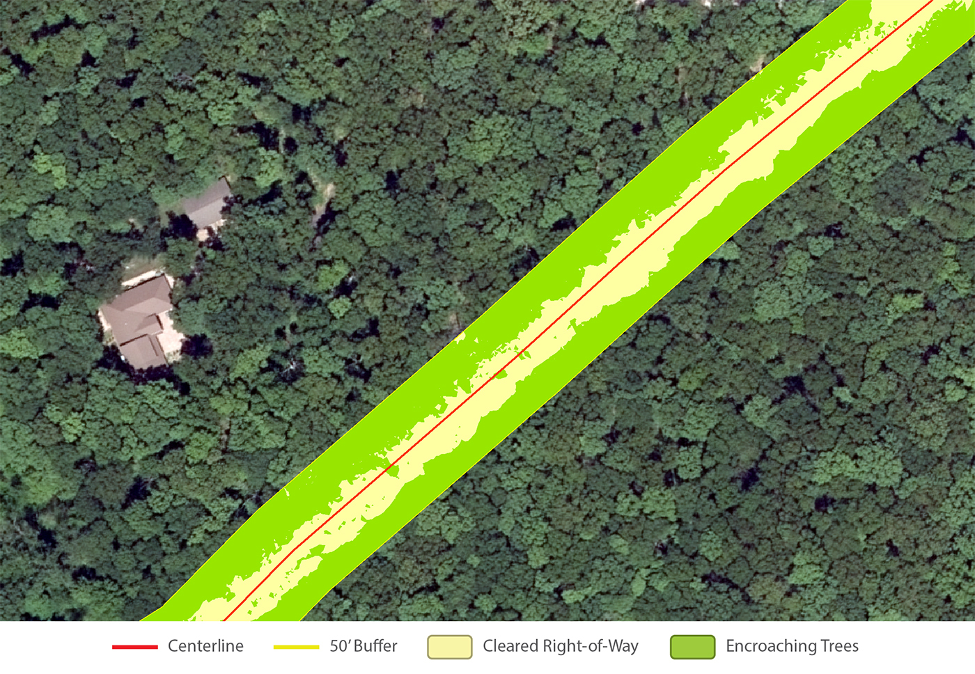
Following are examples of pipeline right-of-ways where encroaching vegetation was detected and quantified using satellite data and Satelytics.
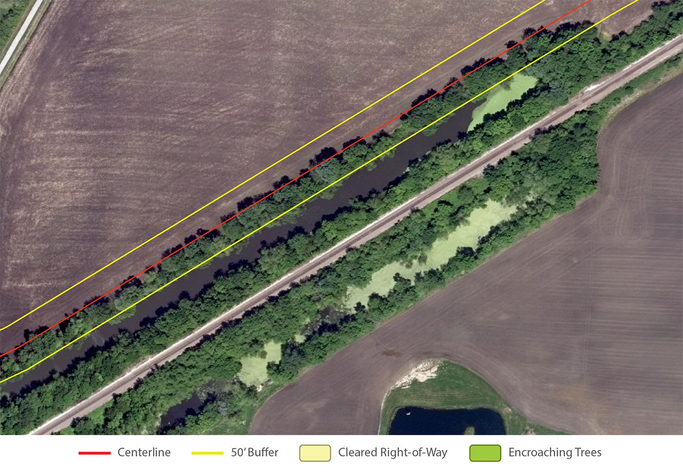
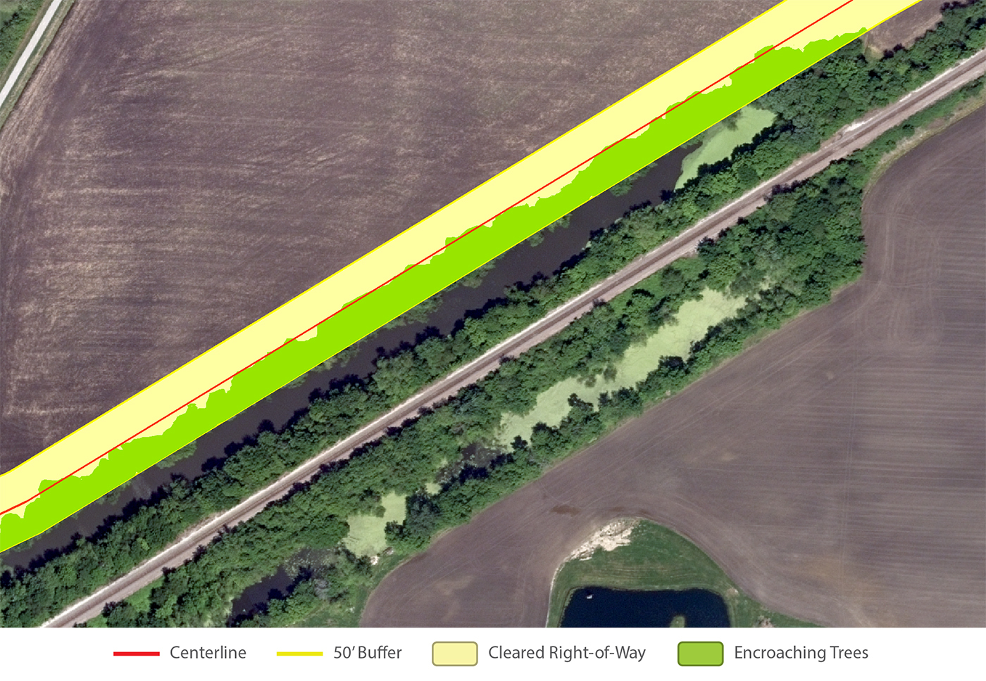
The above image shows a pipeline buffer with a total of 156,486 square feet, and encroaching vegetation of 65,353 square feet, meaning over 40% of the pipeline buffer is covered with encroaching vegetation.
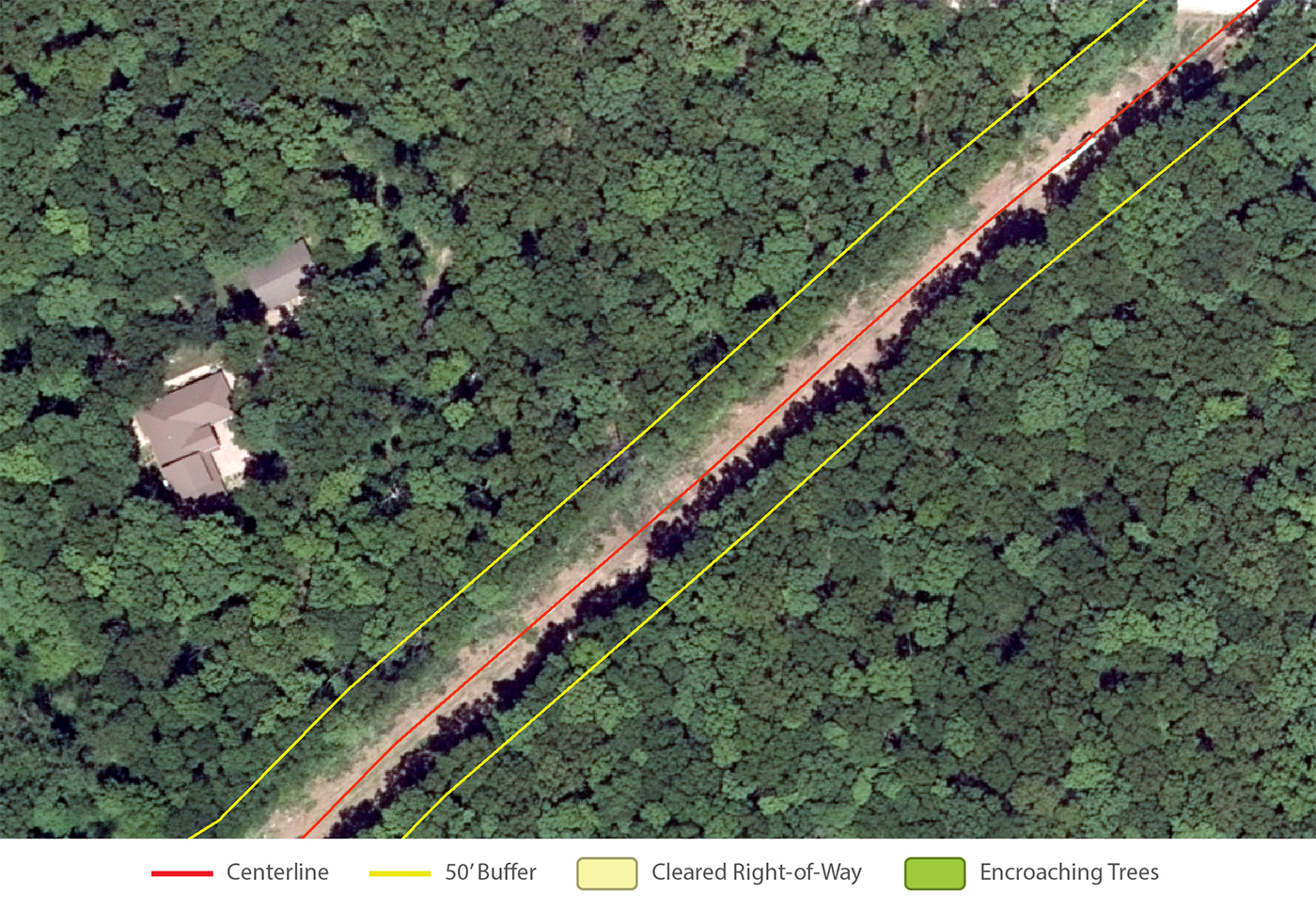
The above image shows a pipeline buffer with a total of 92,876 square feet, and encroaching vegetation of 57,580 square feet, meaning over 60% of the pipeline buffer is covered with encroaching vegetation.
Automated and intelligent information extraction from remote sensing data is the cutting edge of asset management. Satelytics offers a whole suite of monitoring services delivered via cloud software on the Amazon Web Services platform (SaaS). The software suite constantly monitors for a number of impactful operational events, such as right of way vegetation and access monitoring. The solution offers critical infrastructure protection, and allows operators to minimize consequences and significantly mitigate risk.
